 In New Zealand, the Census is usually conducted once every five years. The last Census was due in 2011, but due to the Canterbury earthquakes they were postponed until early 2013.
Following the Census, the country has undergone the Māori Electoral Option, where Māori voters were given the option to choose whether they vote on the Maori roll or the general roll.
Last week, the latest statistics were released showing the number of people enrolled in each electorate following the Census and the Māori Electoral Option.
The statistics show dramatic shifts in the Christchurch area, and a booming population in Auckland, while overall the New Zealand population grew only slightly.
The increasing population in Auckland will require a new seat to be created somewhere in the Auckland area, while post-earthquakes shifts in the Christchurch population will require the seats in central Christchurch to stretch further out into the suburbs to capture the large boosts in population in nearby seats.
Read on for more information, including statistics and a map with clickable information about each electorate.
Under New Zealand law, the South Island is required to have 16 general electorates. The quota is calculated based on the number of potential voters in each South Island electorate to determine how many seats are allocated to Māori electorates and North Island general electorates.
The number of Māori electorates will remain steady at seven for the 2014 and 2017 elections, while the number of North Island general electorates will increase from 47 to 48. This will reduce the number of list seats (assuming there is no overhang) from 50 to 49.
This reflects the fact that the North Island population has grown larger than that in the South Island.
The consequences of this will be that an additional electorate will need to be drawn on the North Island. In addition, changes will need to be made in other parts of the country where electorates vary from the quota. All electorates must be drawn within 5% of the quota. It’s also possible other changes may be made where the numbers don’t strictly require a change.
21 electorates vary from the quota by more than 5% – 16 seats are too large, and five are too small. This is partly due to the fact that the quota is based on 71 electorates, whereas the current map only contains 70 electorates.
The following table shows the electoral statistics for different parts of the country.
| Area | Electorates | Quotas | Electors 2006 | Electors 2013 | Change |
| Auckland | 15 | 15.54 | 863,564 | 928,396 | 7.51% |
| Central North Island | 20 | 20.08 | 1,135,273 | 1,199,155 | 5.63% |
| Christchurch | 5 | 4.67 | 289,597 | 278,749 | -3.75% |
| Māori | 7 | 6.98 | 416,750 | 419,931 | 0.76% |
| North and West of Christchurch | 3 | 2.99 | 168,990 | 178,253 | 5.48% |
| North of Auckland | 6 | 6.35 | 349,087 | 379,482 | 8.71% |
| Outer Christchurch | 2 | 2.22 | 112,264 | 132,272 | 17.82% |
| South of Christchurch | 6 | 6.12 | 349,942 | 365,386 | 4.41% |
| Wellington | 6 | 6.07 | 344,151 | 362,823 | 5.43% |
Rather than using traditional regional boundaries, I have grouped electorates based on their relationship to the three main cities of Auckland, Christchurch and Wellington.
The most dramatic variances are in the Auckland and Christchurch areas.
Electorates in purple are over quota by 5-10%, in red are over quota by over 10%. Electorates in yellow are under quota by 5-10%, in orange are under quota by over 10%.
In the 15 electorates in urban Auckland, the population exceeds the quota by 0.54. Once you add in the six electorates to the north of Auckland, this group of 21 electorates has enough excess population to make up 90% of a new electorate. Add in the two seats immediately south of Auckland, and those 23 seats contain 24.1 quotas of population.
This makes it certain that the new electorate will need to be in the Auckland area, or possibly to the north. Five Auckland electorates, and a further three in surrounding areas, exceed the quota, with three exceeding the quota by over 10%. The addition of a new electorate will have knock-on effects throughout the Auckland region.
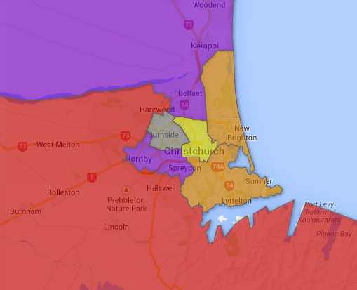
Christchurch’s electorates will require significant redrawing. There are five electorates entirely contained within the Christchurch urban area. Collectively this area has seen a 3.8% drop in the raw number of people living in the area (excluding those counted in the Maori seat) since 2006. This adds up to a deficit of 0.33 quota when it comes to being able to keep five electorates in this area. Christchurch Central has experienced a 7.2% drop, with Christchurch East dropping 17.6%. Port Hills is also substantially under quota. With Wigram substantially over quota.
Most of this loss in population seems to have been absorbed by the neighbouring seats of Selwyn and Waimakariri, which are collectively 22% over quota, and have grown by 17.8% since 2006.
In order to account for population shifts, it seems likely that all five Christchurch urban seats will have to expand outwards to take in parts of Waimakariri and Selwyn that are parts of the Christchurch suburbs.
Selwyn will then also need to gain territory on its southern border from Rangitata, which will need to gain territory from Waitaki. Those seats in the south, north and west of the South Island are all within the 5% variance and won’t require any changes for numerical reasons.
The rest of the North Island will not require dramatic changes, although a few seats vary by more than 5%. The rural National-held seats of Rangitīkei and East Coast are both under quota, while the regional centres of Tauranga and Hamilton East, and Wellington Central, are all over quota.
The seven Māori electorates all sit within tolerance so presumably will undergo minimal change.
