
Victoria is continuing the process of reviewing its local council wards, and since my last update in May, we have started to see proposed ward boundaries for those councils that are being forced to switch to single-member wards following legislative change in 2020 which mandated single-member wards for most urban councils and some regional cities.
Unsurprisingly, some of these single-member wards look completely ridiculous.
Some of these wards cover tiny areas, and the VEC has unsurprisingly had difficulty drawing wards of similar sizes, which will probably force more frequent redistributions over time. For some regional cities, maps have been proposed that involve “wedges” that don’t represent any real community of interest within the council area.
In theory, the review process is meant to provide multiple options, but for the second wave of councils, every option involves single member wards. The “independent” process doesn’t give participants any real choice.
For the first wave, 12 regional councils were reviewed. For each council, an option of electing all councillors at large was proposed, along with a model with 2-4 wards electing 2-4 councillors each, with all wards electing the same number of councils. In some of the councils, a single-member ward structure was also proposed. That review process has concluded, and the final report has been submitted to the Minister, but we don’t know which options were chosen.
The second wave involves 16 councils, with the proposed ward boundaries being released for four councils a week over a four-week period. The first twelve are now out, with the last four due out next week.
In theory, there’s some choice about which model is chosen. Seven of these councils have three different ward maps proposed. Four others have two options. For some reason Yarra only has a single ward map.
The council wards are meant to fall within 10% of the average enrolment per ward, but that’s not much of a range when you’re drawing such a small ward.
Unsurprisingly, in small councils you need to draw quite small wards. Most of the councils in the second wave have been regional cities, but proposed wards have been published for the Melbourne councils of Yarra and Frankston. The Yarra map is a glaring example of the absurdity of the system.
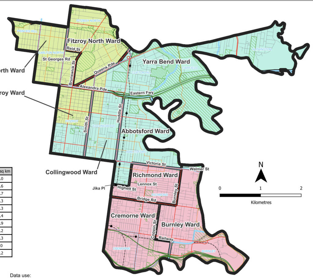
The Richmond Ward covers just 1.2 square kilometres, with 9,123 electors. It takes just five minutes to walk across the ward at the narrowest point, and takes about half an hour to walk from the furthest points across the ward.
The idea that the councillor representing the ward has a distinct interest from the Cremorne or Abbotsford ward is absurd.
These boundaries will prioritise local geography to an extreme degree, and are bound to increase parochialism and nimbyism when it comes to councillor behaviour. It’s also going to make it even harder for renters to become involved in council politics – it’s hard enough to stay living in the same council area when it’s as small as Yarra, let alone staying in the same ward. And of course these lines are completely arbitrary, having to achieve numerical equality by zigging and zagging across a small area.
There’s also some absurd boundaries proposed for some regional cities.
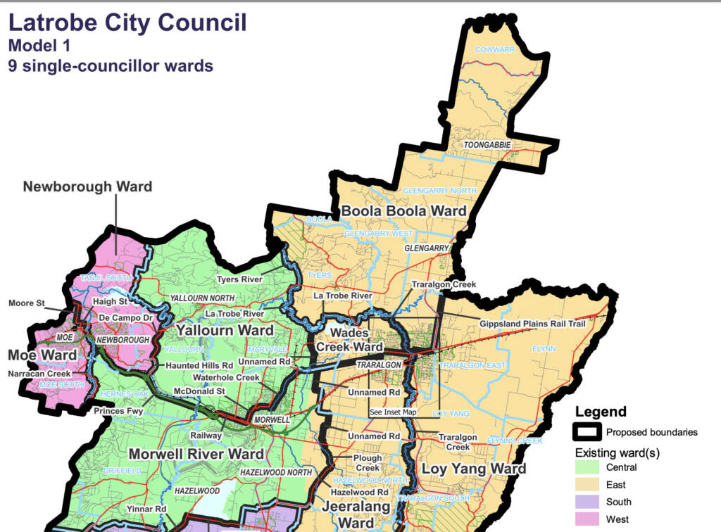
In Latrobe, the towns of Traralgon, Morwell and Moe have had to be divided down the middle to achieve numerical equality.
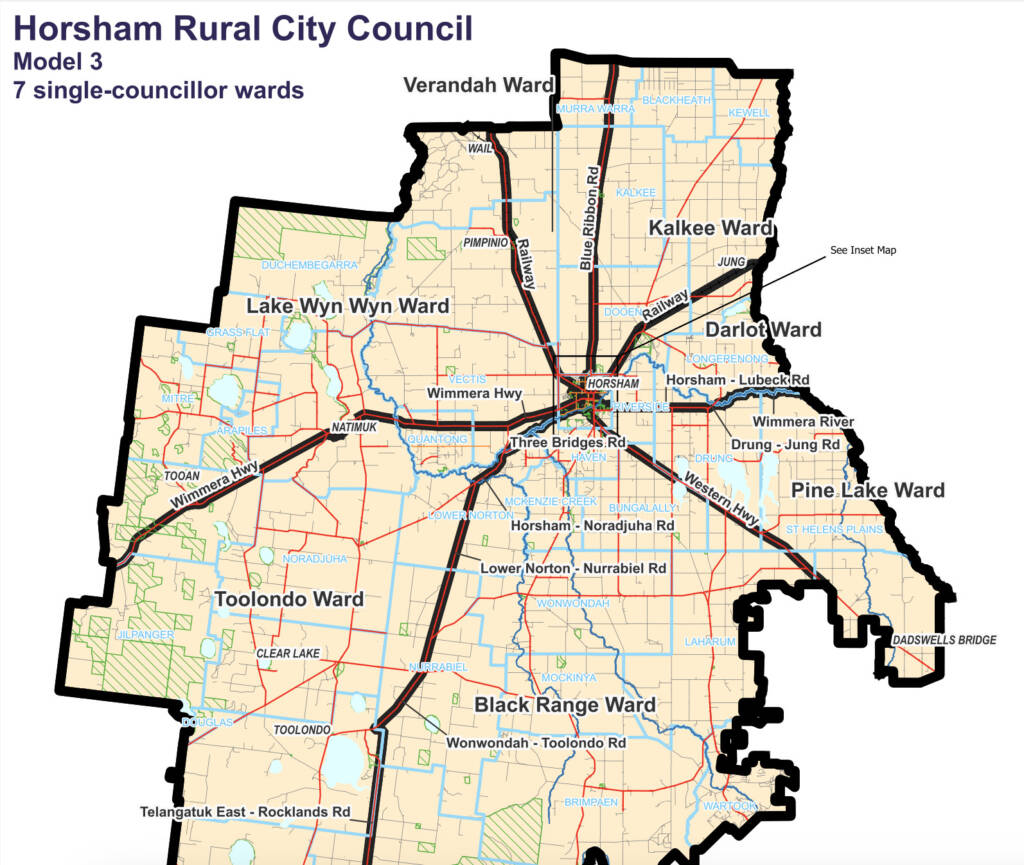
Meanwhile in Horsham, they have proposed one option that sees all seven wards as wedges stretching from the centre of town to the council boundary.
Honestly these electoral system changes are kind of embarrassing for Victorian local government and it’s worth remembering it.
Victorian local government, particularly in Melbourne and large regional cities, will be divided up into much smaller wards than in South Australia or New South Wales while Tasmania doesn’t have any wards at all. Even Western Australia is moving in the right direction. Yet here Victoria is standing out again.

That Horsham map is hilarious. Actually got a chuckle out of me. Reminds me of that post-WWI proposal to divide Europe into “cantons” that radiated out from Vienna.
In the city of Greater Geelong, Option 1 includes a Cowies Creek Ward which includes much of the rural north, a working class northern suburb carved out from the others and then a small portion of wealthy Highton, far to the southwest, to make up the numbers. All three areas have no community of interest. In Option 2 there is a ward that stretches almost the entire width of the council in order to join the small coastal villages of the eastern Bellarine with the rapidly growing Armstrong Creek about 50km west and across a huge geographic divide – Lake Connewarre. I have played around with the maps myself and have found there are plenty of alternative divisions that don’t rely on these kinds of arrangements.
The Latrobe council wards wouldn’t be as bad if single wards were consolidated around Moe, Morwell and Traralgon but the population of surrounding towns is just too small so they get spit into different wards.
Also that Horsham proposal looks completely ridiculous.
One proposal for the Northern Grampians councik splits Stawell in half and in the Campaspe council one proposal split Echuca.
Who proposed dividing Europe into Viennese cantons?
It is a great shame that the progressive reforms to local government introduced under the Bracks Government have been wound back by a decision made by Mr Adem Somyurek, whose character and record of activity is dubious to say the least. Single member wards in small councils lead to increasing number of uncontested elections, and fail, often dismally, to represent the diversity of opinion in a Council area.
https://bigthink.com/strange-maps/a-bizarre-peace-proposal-slice-europe-up-like-a-pie/
I found an article about the circular cantons here and it’s even worse than I though it’d be
Comments are closed.