
The most marginal seat in South Australia is Newland, in the north-eastern suburbs of Adelaide. The seat was won by the Liberal Party by a 2% margin in 2018, but my redistribution model estimates the seat as a super-marginal Labor seat, while Antony Green’s estimates keep the seat on the Liberal side of the pendulum by a sliver.
But the race is made even more interesting by the intervention of Frances Bedford, a sitting independent MP for the neighbouring seat of Florey. Bedford has represented Florey since 1997, serving as a Labor member until 2017.
Bedford’s departure from the ALP, and her recent decision to switch seats, were both triggered by shifts in electoral boundaries, moving Florey away from its historical location, about five kilometres to the north-west. In this post I’ll map how those areas have shifted, and look at how Bedford’s vote was split between different electorates in the most recent redistribution.
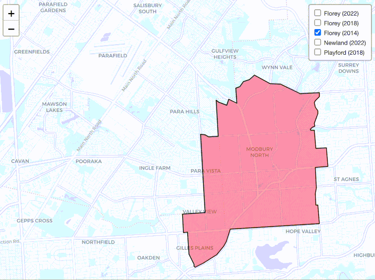
I’ve made a map showing the boundaries of Florey at the three most recent elections, as well as the 2022 Newland boundaries and the 2018 boundaries of Playford, both of which are relevant to this conversation.
I have South Australian electoral boundary maps dating back to Bedford’s first election in 1997. From 1997 until 2014 there wasn’t much change in Florey. The 2014 electorate covered Modbury, Modbury North, Modbury Heights, Para Vista, Ridgehaven and Gilles Plains.
The 2018 redistribution shook up Florey, shifting the electorate to the west, taking in Ingle Farm, Pooraka and Walkley Heights, while losing Modbury Heights, Ridgehaven, Gilles Plains and parts of Modbury. Most of those new areas came from Playford, while the lost areas were mostly split between Newland and Wright.
Playford MP Jack Snelling, a former treasurer who was still serving as a minister in the Weatherill government, defeated Bedford for Labor preselection. Bedford resigned from the party and contested the seat as an independent, and Snelling decided to retire rather than contest the seat.
The most recent redistribution took Florey even further, shifting north to take in Mawson Lakes, Para Hills and Para Hills West from Playford. Florey lost its southern and eastern ends. These areas were divided up between Enfield, Newland, Torrens and Wright.
By the end of this process, only a small strip of land in Para Vista remained as a continuity between the 1997-2014 Florey and the 2022 Florey.
This gif demonstrates the north-western journey:
This account of how the boundaries have changed suggests that the Florey of 2022 is no longer the same as the Florey of 2014, but you can also see this trend by looking at the voting data.
I’ve looked at the data from my redistribution estimates, and how I split up the 2018 Florey results between the 2022 electorates which took in parts of the seat.
| 2022 electorate | 2018 Bedford prim (%) | 2018 Bedford 2CP (%) | Share of Florey 2018 (%) |
| Enfield | 25.2 | 55.2 | 11.3 |
| Florey | 27.2 | 50.8 | 50.9 |
| Newland | 41.5 | 68.8 | 14.3 |
| Torrens | 28.9 | 56.8 | 16.9 |
| Wright | 47.5 | 69.2 | 6.7 |
Just over half of the electorate has stayed in Florey, and that area was just barely won by Bedford in 2018.
Bedford polled under 30% of the primary vote, and less than 57% of the two-candidate-preferred vote, in the areas moved into Enfield and Torrens, but did much better in those parts moved into Newland and Wright.
Once you look at those numbers, it makes a lot of sense that Bedford would look to jump, and Newland is the best option, but the Newland of 2022 is not a recreation of the Florey of 2014. You can see this clearly by toggling on those two maps in the embedded map above.
While Modbury North and Modbury were in Bedford’s historic seat and are now in Newland, it also includes areas further east, including Banksia Park, St Agnes, Tea Tree Gully and Yatala Vale.
Independent MPs often cement their position by building up a personal vote with a particular community, but Bedford’s community has been broken up under her. Newland may include her heartland areas, but also includes a large area she’s never represented.
One other thing worth noting: South Australia uses a lot of names of people for their state electorates. This is relatively unusual: most states mainly use geographic locations for electorate names, although there are exceptions. Queensland did name a number of seats after people in their last state redistribution. This is in contrast to federal electorates, which are now mostly named after people and aren’t tied to a geographic area.
If you used a geographic electorate name, the old Florey would’ve likely been called “Modbury”, and the electorate would have been renamed as it shifted north-west, even if we recognised that it was a successor electorate over the course of a single redistribution. Yet abstract names can survive, giving the impression an electorate has continuity even as it covers an entirely different area.

I wonder if the shifts in Florey and all surrounding northern Adelaide districts is due to the population growth in the Salisbury-Elizabeth corridor. I recall that Parafield and Mawson Lakes (which are now in Florey 2022) were in Ramsay pre 2010 which has now contracted to cover just Salisbury and its immediate surrounds.
The rapid pace of recent changes in boundaries compared to the long period of stability in the 90s and early 2000s is similar to other districts, such as the federal seat of Corangamite in Victoria. It stayed pretty constant for a while in the 2000s, but then changed dramatically over 2 redistributions to shed Colac and then the Surf Coast as it contracted to just the Bellarine peninsula and the outer suburbs of Geelong.
I think your commentary says “east” a few times when it should say “west”. Third para – “five kilometres to the north-east”, fifth para – “shifting the electorate to the east” and above the gif – “the north-eastern journey”.
Oh thanks.
Comments are closed.