 The City of Brisbane is unlike any other council in Australia. With a population of over one million people, the council is much larger than metropolitan councils in other Australian cities.
The election for Lord Mayor of Brisbane is the largest single-member election in Australia, with over 550,000 people voting in the 2012 election. This is much more than in a federal electorate. The council consists of 26 councillors, each elected from their own ward. Those 26 wards are also quite large – almost as large as Queensland state seats.
Considering all this, elections for the City of Brisbane are more like a small state election than any other local council election around Australia. With this in mind, I’m planning to cover the March 2016 Brisbane election in the same way I have done for recent state elections, with a guide for each ward.
In the meantime, the Electoral Commission of Queensland is currently undertaking a redistribution of Brisbane’s wards for the 2016 and 2020 elections. The last redistribution took place before the 2008 election, and the current wards have been used for two elections.
In this post, I’m looking at what changes may need to be made to the existing ward boundaries.
At the last redistribution before the 2008 election, the ward of Grange was abolished in the north of Brisbane, and was effectively replaced by a southern ward. In exchange, the seat of Walter Taylor lost the one third of its territory on the southern side of the river. This effectively cut the number of wards north of the river from 12.7 to 12. It seems likely that some of these trends will be reversed in this redistribution.
The ECQ has released enrolment figures for each ward as of 2014, as well as projects for 2016 and 2018. All wards must be within 10% of the quota in 2014, and it’s a good idea to also try and draw boundaries that keep wards within that quota by 2018.
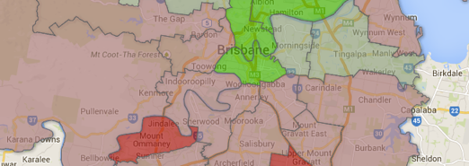
For my analysis I have split Brisbane into four quarters. There are twelve wards north of the river and fourteen south of the river. For the wards south of the river, I have split them into two quarters of seven wards each. The south-east covers The Gabba ward in South Brisbane and all those wards to the east of the M3, while the south-west covers the remaining wards south of the river.
The north-west covers Central ward (covering the Brisbane CBD) and wards further west covering areas like Indooroopilly, Ashgrove and Moggill. The north-east covers areas to the north and east of the CBD.
| Region | Enrolment | Wards | 2014 variation | 2016 variation | 2018 variation |
| North-East | 167,584 | 6 | 20.37 | 24.53 | 28.23 |
| North-West | 162,855 | 6 | 2.86 | 6.11 | 3.07 |
| South-East | 188,911 | 7 | -0.68 | -3.67 | 0.53 |
| South-West | 183,002 | 7 | -22.55 | -26.97 | -31.83 |
Overall, the north-west and south-east are close to quota. There are some seats over quota – Central is 10.2% over quota already, and The Gabba is expected to be more than 10% over quota by 2018 – but theoretically these issues could be resolved by minor changes between neighbouring wards rather than major structural changes to the whole city.
However the north-east is well over quota and the south-west is well under quota. By 2018, the north-east will have enough extra voters for 28% of an extra ward. By 2018, the south-west’s population will fall 31.8% short of justifying a seventh ward.
In order to resolve these differences, wards will need to shift north from the south-west to the north-east. Since these two regions don’t border each other, it will require significant changes to some wards in one of the regions where the population is on quota.
In particular, it will be necessary for one of the wards to cross the river. At the moment, there is no ward crossing the river. In the past, the Walter Taylor ward (covering the Indooroopilly area) has included areas on the south side of Brisbane, and the Indooroopilly state seat is currently the only Brisbane seat to cross the river. Because of this, it seems likely that a ward will cross the river in this area.
So the most likely trend seems to be:
- Seats in the south-east undergo minor changes, with the Gabba shrinking and giving territory to Holland Park, and Holland Park and three of its neighbours all expanding slightly to absorb the growth from the Gabba. The surplus from Doboy will bring Wynnum-Manly up to quota relatively simply.
- In the south-west, Parkinson will shrink, but all of its neighbours will have to grow, in particular Jamboree and Macgregor. This will require one of these wards, probably Tennyson, to jump the river and take in about 8000 voters.
- The wards of Walter Taylor, The Gap and Toowong all will require substantial more population, which will probably result in significant redrawing of their borders and a general shift to the north-east. This will include taking in substantial parts of Central ward, which is well over quota.
- Bracken Ridge will likely give some of its territory to Deagon to bring them both into quota, and McDowall will take population from Marchant to bring them into quota. No changes are necessary to Northgate.
- Hamilton is due to be way over quota, and with Northgate not needing changes, most of this population growth will need to be discharged into Central ward. With Central giving up some of its territory to Toowong, this will result in Central shifting towards the north-east.
You can find out more about the redistribution at the ECQ website, and submissions close on December 22.

Ben, the only realistic opportunities for a southern Ward to cross the Brisbane River, taking transport links, communities of interest and the barrier that the river is into account, are in the City area (unlikely), Indooroopilly and the Fig Tree Pocket/Kenmore area.
One solution may be to add Fig Tree Pocket to Jamboree Ward (although that’s only been done once when Ryan went across the river to take the Jindalee suburbs) and add Indooroopilly to Tennyson Ward. You couldn’t have Fig Tree Pocket connected to a Ward containing St Lucia which doesn’t include Indooroopilly. Perhaps it could be added to the Pullenvale Ward.
Unless the Gabba Ward crosses the river, my guess is that Tennyson will take Indooroopilly and perhaps Fig Tree Pocket and lose the Yeronga area. Walter Taylor Ward will move north-west, as will the Toowong, The Gap and Enoggera Wards. Central will lose its northern suburbs and Marchant will lose its southern suburbs.
My dim dark memory tells me that prior to 1994, legislation (the City of Brisbane Act?) specified that there would be 13 Wards north of the river and 13 south of the river. (A silly requirement if there every was one.) One then-Liberal Councillor complained about reforms which removed this requirement.
Comments are closed.