NAT 50.82% vs LAB
Incumbent MP
Shane Ardern, since 1998.
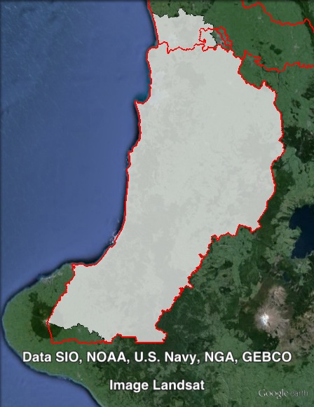
Geography
North Island. Taranaki-King Country covers a large stretch of the west coast of the North Island, stretching from areas to the south and west of Hamilton in the north, to Mount Taranaki in the south, covering areas close to New Plymouth. The electorate covers all of Otorohanga and Waitomo council areas, and parts of New Plymouth, Ruapehu, Stratford, Waikato and Waipo council areas.
Redistribution
Taranaki-King Country shifted north, losing a small area on its southern border to Whanganui, and gaining territory from Hamilton West and Waikato at the northern end of the electorate. These changes slightly increased the National margin from 50.4% to 50.8%.
History
Taranaki-King Country was created as a new electorate in 1996. The seat has always been held by the National Party. The seat mostly succeeded the seat of King Country, which had been National-held since its creation in 1972. It also took on parts of Taranaki, Waitotara and Waipa electorates, which had all been held by the National Party continuously since their creation in 1978.
King Country was won in 1972 by National candidate Jim Bolger. Bolger joined the ministry in 1975, and served in the Muldoon National government from 1975 to 1984.
Bolger became deputy leader of the National Party after the party lost power in 1984, and became Leader of the Opposition in 1986. He led the party unsuccessfully at the 1987 election, and then won power in 1990.
Bolger served as Prime Minister from 1990 to 1997. In 1996, the introduction of MMP resulted in his electorate being expanded and renamed Taranaki-King Country.
Bolger resigned from Parliament in 1998 to take up the position of Ambassador to the United States. This triggered a by-election in Taranaki-King Country.
At that by-election, the National vote collapsed to 29.4%, with the ACT candidate second on 24.6%. National candidate Shane Ardern held on, and finished Bolger’s term.
Ardern won easy re-election in 1999, 2002, 2005, 2008 and 2011.
Candidates
Sitting National MP Shane Ardern is not running for re-election.
- Edward Ash (Conservative)
- David Espin (Democrats #25)
- Penny Gaylor (Labour #45)
- Grant Keinzley (Internet #22)
- Barbara Kuriger (National #58)
- Robert Moore (Green #50)
Assessment
Taranaki-King Country is a very safe National seat.
2011 election results
| Electorate Votes | Party Votes | ||||||||
| Candidate | Party | Votes | % | Swing | Redist | Votes | % | Swing | Redist |
| Shane Ardern | National | 20,842 | 69.65 | +0.97 | 69.44 | 18,759 | 60.44 | +0.90 | 60.84 |
| Rick Barker | Labour | 5,753 | 19.22 | -0.33 | 18.62 | 4,950 | 15.95 | -5.24 | 15.48 |
| Robert Moore | Green | 2,819 | 9.42 | +1.01 | 9.21 | 2,554 | 8.23 | +3.25 | 8.32 |
| Victoria Rogers | United Future | 511 | 1.71 | +1.71 | 1.44 | 340 | 1.10 | +0.30 | 1.13 |
| New Zealand First | 0.63 | 2,252 | 7.26 | +2.76 | 7.12 | ||||
| Conservative | 0.49 | 1,180 | 3.80 | +3.80 | 3.81 | ||||
| ACT | 0.06 | 461 | 1.49 | -3.57 | 1.48 | ||||
| Māori | 209 | 0.67 | -0.34 | 0.71 | |||||
| Legalise Cannabis | 181 | 0.58 | +0.23 | 0.59 | |||||
| Mana | 83 | 0.27 | +0.27 | 0.29 | |||||
| Democrats | 0.06 | 25 | 0.08 | -0.17 | 0.10 | ||||
| Alliance | 24 | 0.08 | -0.01 | 0.07 | |||||
| Libertarianz | 20 | 0.06 | +0.01 | 0.07 | |||||
| Other independents | 0.05 | ||||||||
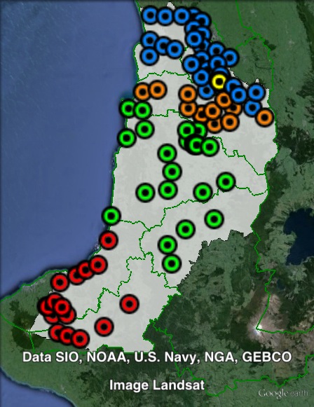
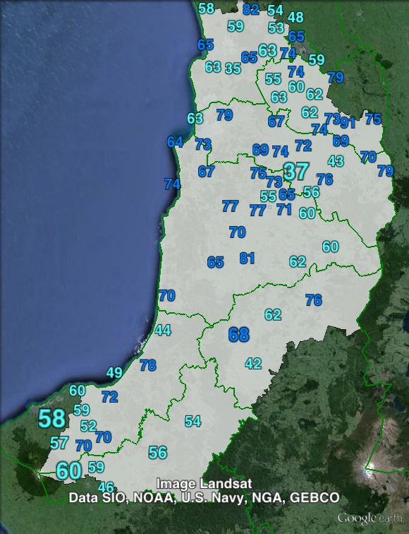
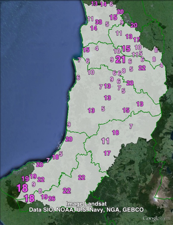
Booth breakdown
Booths in Taranaki-King Country have been divided into five areas. The largest town in the electorate is Te Awamutu, and polling places in this town have been grouped together. Those polling places in the Otorohanga council area have been grouped together. The remaining council areas have been split between:
- Central – Ruapehu and Waitomo council areas.
- North – Waikato and Waipo council areas, except for booths in Te Awamutu urban area.
- South – New Plymouth and Stratford council areas.
National won large majorities in all five areas: 66-76% of the electorate vote, and 57-67% of the party vote. Labour came second across the seat, although the Green Party narrowly outpolled Labour on the party vote in Otorohanga. The Green vote is much stronger in Otorohanga than in the rest of the seat.
| Voter group | Electorate votes | Party votes | Total | % of votes | |||||
| NAT | LAB | GRN | NAT | LAB | GRN | NZF | |||
| North | 70.48 | 18.04 | 7.21 | 61.96 | 14.69 | 7.62 | 7.26 | 6,518 | 21.20 |
| South | 66.20 | 22.11 | 8.44 | 57.64 | 18.82 | 6.40 | 9.20 | 5,926 | 19.28 |
| Central | 75.72 | 14.25 | 8.06 | 67.06 | 11.61 | 7.72 | 5.22 | 5,375 | 17.48 |
| Otorohanga | 66.86 | 17.08 | 14.78 | 59.15 | 12.95 | 13.20 | 6.22 | 3,208 | 10.44 |
| Te Awamutu | 67.83 | 22.54 | 8.33 | 56.63 | 18.78 | 6.86 | 8.78 | 2,689 | 8.75 |
| Other votes | 68.17 | 18.78 | 10.41 | 60.17 | 16.18 | 9.37 | 6.46 | 7,025 | 22.85 |