 The NSW government has released its plans for council amalgamations following a lengthy of period of reviews and submissions by local councils.
The government is proposing cutting the number of councils in the Sydney region from 43 to 25, as well as merging other councils in rural NSW.
In this post I’m going to focus on the changes to the region stretching from Port Stephens to Shoalhaven, covering the vast bulk of New South Wales, including about 6 million residents.
This region includes 53 councils, and the NSW government proposes reducing this to 32 councils, with only 14 councils unaffected.
I’ve done some analysis of the political make-up of each new local government area, examining allegations of gerrymandering, and posting some maps showing the stats for each proposed new council.
You can download the Google Earth map of the proposed boundaries here. (link broken)
You can also download the dataset I used here.
My map does not cover rural areas – it only stretches from Port Stephens to Shoalhaven.
Firstly, I’m not going to deal with the question of whether councils should be amalgamated, whether they should be forcibly amalgamated, or specifically whether the NSW government’s approach is correct. I’ve previously analysed the flawed IPART report, and will instead focus on describing the councils as proposed.
For this analysis, I have used federal election results to analyse the underlying political make-up of any council. This is the easiest data to access – it would have also been interesting to see the council election results for the new councils, but council results are often quite dependent on who runs, and in a bunch of councils there are no political parties running, which would limit the value.
I calculated the Liberal two-party-preferred figure (vs Labor) for the 2013 federal election. I then subtracted 3.5% from the Liberal vote to adjust the vote to a situation where the NSW vote was 50/50.
This map shows the political make-up of each council before the mergers.
There’s some interesting trends in areas affected by the redistribution. The old Parramatta council is marginally pro-Labor (54.1%), while Burwood, Strathfield and Canada Bay are also quite marginal – ranging from 54.8% Labor in Burwood to 51.5% Liberal in Canada Bay.
In the eastern suburbs, Randwick is marginally pro-Labor while Waverley and Woollahra are solidly pro-Liberal.
Now let’s look at the same data for the proposed councils.
Marginal Liberal Ryde has become solidly Liberal with the addition of Hunter’s Hill and Lane Cove.
Parramatta remains marginally pro-Labor, although less so than the old Parramatta.
In the east, the council I have nicknamed ‘East Sydney’ is 55.7% Liberal, wiping out any pro-Labor leanings in Randwick.
I think there are some interesting cases where you can argue that the Liberal government may have engaged in some gerrymandering:
- Burwood and Canada Bay agreed to merge with Auburn, which would have required Strathfield to be included as well. Instead the government has created this new council without Auburn. With Auburn the council would have been 54.3% Labor, without 50.2%.
- Parramatta has been expanded slightly north to take in pro-Liberal suburbs south of the M2 (which seems to make sense), but instead of expanding south to take in pro-Labor Holroyd and Auburn, the government will remove South Granville and Granville (some of the most Labor-friendly parts of Parramatta) and roll all those Labor areas into a strange-looking council to the south of Parramatta. If you included these areas into a larger City of Parramatta, it would increase the Labor margin from 50.4% to 55.4%.
- Randwick is marginally Labor, and combining it with pro-Liberal Waverley and Woollahra has produced a much larger pro-Liberal council. Inclusion of Sydney or Botany Bay (as proposed by the independent panel) would have weakened this considerably).
- Kogarah is marginally pro-Liberal, and will be merged with Hurstville to create a marginal pro-Labor council, but it would have made a lot of sense to include Rockdale in a larger St George council, and they didn’t. Excluding Rockdale reduced the Labor margin from 52.6% to 51%, while also significantly weakening Labor’s hold on Botany Bay council (which considering its democratic deficit, is probably a good thing).
- Ryde council, which has always been marginal, will shift more towards the Liberal Party with the addition of more parts of the North Shore.
- The old Newcastle had a pro-Labor margin of 63.9% and with the addition of pro-Liberal Port Stephens this has dropped to 58.4%. The alternative option of merging with Lake Macquarie would have not produced any weaker margin.
Now it’s possible to argue some of these cases on grounds other than partisan gerrymandering – Ryde and the East Sydney proposal make a decent amount of sense, but the Parramatta proposal really only makes sense as a way to hive off strong Labor areas from a strategically-important city (in the same way past Liberal governments hived off Labor-voting suburbs in the City of Sydney to form various South Sydney councils).
Probably the only Liberal-leaning councils which could feel aggrieved by this proposal are Canada Bay and Kogarah, but these councils only lean slightly towards the Liberals (and are in areas where they did particularly well in 2013). In both cases the Liberal Party’s amalgamation logic wouldn’t have allowed those councils to stand along, and in both cases they kept out more pro-Labor councils which would have shifted the new councils further towards Labor.
It’s also worth noting that these margins suggest underlying trends and councils can vary from that. They also don’t factor in personal votes for federal MPs which could see certain councils diverge from their underlying ideology. Waverley in the past has had progressive majorities (and was half-progressive until 2012) despite being a strong Liberal area at a federal level. Newcastle likewise had a conservative majority until recently despite an overwhelming Labor vote federally, and a series of Labor-leaning Western Sydney councils are controlled by Liberals after the 2012 council elections.
But council amalgamations are not just for the next election cycle – they should be in place for a long time, and underlying political trends will influence their make-up. Putting a thumb on the scale to push a council a few points one way or the other might make a difference in which political grouping wins a majority.
One other thing I want to look at is population. One of the goals of this process was to have similarly-sized councils across Sydney.
Firstly, here is the map of existing council populations:
There’s a lot of variation. Only Blacktown is over 300,000, while there are eight councils in central Sydney under 50,000 population and a further ten in the centre of Sydney with a population under 100,000.
This looks much more equal under their proposals:
Most of these new councils aren’t some new creature – they’re roughly in line with the large councils of Western Sydney, with most having populations between 100,000 and 200,000 people.
There are two proposals that stand out as strange.
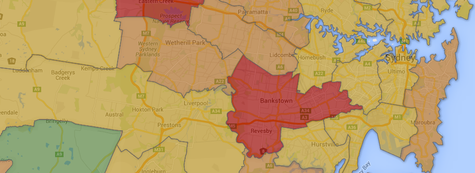
Firstly, the merger of Canterbury and Bankstown doesn’t appear to make sense when considering the rest of these proposals. While the councils have a lot in common, geographically it creates a strange shape, with about 20km between Earlwood and Chester Hill.
It’s also not necessary to achieve an even population balance. Bankstown is already over 200,000 residents: about the same as Fairfield, Liverpool and Penrith, and more than Campbelltown, yet none of those councils are being merged.
Canterbury’s current population of 150,000 is similar in scale to the proposed Hurstville-Kogarah, Botany Bay-Rockdale and Burwood-Canada Bay-Strathfield mergers happening around it.
Instead, by merging two councils which are already at a similar scale to neighbouring post-merger councils, Bankstown-Canterbury becomes the most populous local government area in New South Wales.
Secondly, the state government decided to split Warringah in half and give each half to Pittwater and Manly, instead of merging the three councils to form a Northern Beaches council. While the state government has attempted to clear up messy and non-intuitive boundaries around Parramatta, they have done exactly the opposite by drawing a new local government boundary through the backstreets of Warringah.
Finally, a note on council names. The state government hasn’t proposed names for any of these councils – and even if they did there’s a history of dry state-designed names being quickly replaced by a new council, such as when Eastern Capital City Region became Palerang.
I’ve made up names for most of the new councils for ease of use and wanted to explain them. For a number of the new councils, I have kept the name of the constituent council which is clearly dominant: Parramatta, Manly, Pittwater, Wollongong, Newcastle, North Sydney, Shoalhaven and Ryde. I’ve also retained the names Strathfield and Botany Bay, despite those councils making up a minority of the new council, since the names seem generally applicable.
I’ve made up the following names:
- Central Coast – Gosford and Wyong
- East Sydney – Randwick, Waverley and Woollahra
- Hawkesbury Hills – Hawkesbury and the Hills
- Petersham – Ashfield, Leichhardt and Marrickville
- St George – Kogarah and Hurstville
I don’t have a good name for Auburn-Holroyd, Bankstown-Canterbury or Hornsby-Ku-ring-gai.

You could call Canterbury-Bankstown Bulldogingham or Bulldogia or something
I wouldn’t be surprised if it took the name the City of Canterbury-Bankstown given that the Canterbury-Bankstown Bulldogs.
The new Upper North Shore council could be named Oxley as the area was known as the Oxley district (subdivision of Cumberland County) according to an old map from 1824.
It’s less clear what the merger of Holroyd and Auburn could be called, mainly because it doesn’t include all of Granville.
Yeah I originally called it Granville but Granville station is right on the edge of the LGA.
Nice post. I find it really odd that the government isn’t trying to merge Rockdale-Kogarah-Hurstville to form a single City of St George Council. It seems the most natural fit of any in Sydney. This would have also cleared up the horrible boundary between Rockdale and Kogarah councils. I was hoping they would split and divide Botany Bay Council between Syd City and the new East council.
Yep I agree. The internal boundaries in the St George area are probably the worst in Sydney – all three suburbs which give their name to a council (Hurstville, Rockdale, Kogarah) cross council boundaries. The idea that you would undertake major changes and leave that alone seems absurd.
I think it’s partly about Botany Bay being stranded with no-one to pair with. The eastern suburbs don’t want it, the CoS doesn’t want to merge (and the Liberals wouldn’t want to), and leaving it alone would look silly when they’ve set this minimum floor for council population.
Either that or just wanting to keep Rockdale apart from the rest of the St George, but it’s not that strongly pro-Labor.
Some curious decisions there. I would think that local government level political factors, alliances and power-bases would be a bigger indicator in terms of the gerrymandering question than what we can tell from the federal or state 2PP trends, so it would be interesting to see any observations from people involved in local government politics in some of these areas as to how they interpret the political impact based on their local politics. Ben mentions for example Waverley and Newcastle as areas where local government politics diverges significantly from the federal trend. Presumably given council-level trends, the merger with Port Stephens would definitely advantage conservatives in Newcastle more than the 2PP trend suggests. Kiama, iirc, at least before 2012, had a progressive majority council, but it gets swallowed up by Shoalhaven which seems to be even more conservative-dominated at a council level than the 2PP suggests.
In the remainder of NSW I found the Dungog-Gloucester merger the most curious, as they were both small councils which one might’ve expected to be merged with larger neighbours rather than each other. The merger of Armidale and Guyra, plus Walcha with Tamworth, strangely leaves Uralla alone in between them. There had been a proposed forced merger of Armidale, Guyra and Uralla under the Keneally government, so it seems odd Uralla is now left on its own.
And many of the very small population councils in the Riverina being merged was arguably expected decades ago.
Re names I tip Eastern Beaches for Randwick-Waverley-Woollahra.
@Ben Raue. Totally agree with you in regard to the absurd situation of suburbs which give their name to a council (Hurstville, Rockdale, Kogarah) crossing council boundaries. This situation currently also occurs where parts of the suburb of Strathfield are within Burwood Council. Thankfully in this instance it’s being remedied.
@Ben Raue. And also parts of the suburb of Strathfield are currently within Canada Bay Council! To think they wouldn’t address these abnormalities in the St George area is absurd.
Split of Palerang Shire Council between Queanbeyan and Goulburn doesn’t seem to work all that well in terms of connections and regional interests – particularly at the southern end
Does the split of Palerang follow previous shire boundaries or is it a completely new delineation?
Thanks for doing a more solid analysis regarding the allegations of “gerrymandering”. I had read the IPART report and the Fit for the Future reports as well as the final recommendations the other day with some interest as my partner and I have worked for a number of Council’s and so follow them with interest.
There seemed to be no consistency from one report to the next and I had hoped to see a political one – although as you point out even that can be hard to analyse. Thanks all the same though because I believe you have found some evidence for this.
I think the reforms are mostly sensible, but there are two standout shockers:
1. Holroyd-Auburn. This area clearly falls within Parramatta’s sphere of influence. It’s ridiculous that Parramatta is actually ceding territory under this proposal Just look how close the boundary runs to the Parramatta town centre. Taking in all of Holroyd and Auburn would create a nicely sized new City of Parramatta.
2. Rockdale-Botany. This is a bizarre pairing as one always thinks of Rockdale as belonging to St George and Botany to the eastern suburbs. There isn’t even much contiguity here as Kingsford Smith airport divides the present two LGAs.
It’s a bit disappointing that they didn’t make more of an effort to tidy up the external boundaries. Many council boundaries in Sydney run along minor back streets or make strange dog-legs, and I would have thought they would have used this opportunity to realign them.
They did that with Parramatta (using M2 and M4) but not really elsewhere.
Not sure on the history of the Palerang split – but the connections at the southern connect much more logically to Queanbeyan and Eurobodalla – Araluen is a good example
Adjusting the Parramatta-Hornsby boundary northwards to the M2 is generally sensible, but there’s a glaring debacle in North Epping, which would be a landlocked little pocket of Hornsby accessible only via lengthy detours through Parramatta or Ryde Council territory. The M2 is in a tunnel along the Epping-North Epping boundary anyway, so the physical barrier that it creates elsewhere is not an argument to leave North Epping with Hornsby. It will be a long way for the Hornsby Council garbage trucks to drive just to service those few streets…
Including Mosman with Manly is rather crazy.
Let’s see which of the new Pittwater and Manly inherits the sackability of Warringah council.
It really should be one council with only around 180,000 people for the whole of the north beaches
Thanks Ben, To me the decision not to put Botany in with City of Sydney shows most clearly the politics in some of these decisions. State governments have been planning the corridor from the city to the airport as the hub of the global city Sydney for over a decade. Adding Botany to the city would be a clear expression of that at the local level. However, I suspect bringing Labor voting Botany into the City would reduce even further the Liberal Government’s ability to control the City. I’m sure the Lib’s learnt as much as Labor last time the boundaries of the City were changed. But Rockdale/Botany is just wrong
Lots of silly decisions here…one that hasn’t been covered in the comments though..
Lower North Shore – makes much more sense to group nth Sydney, Willoughby, lane cove and hunters hill
Ryde has no community of interest with the lower North shore. The Epping area is well connected with Ryde via the northern rail line and both the parramatta and Hornsby parts should go to Ryde.
Yes Epping is a better fit with Ryde. The Parramatta/Ryde boundary already partially uses Pennant Hills Rd, it could easily be utilised all the way north to the M2. In addition you could also move North Epping into Ryde, to solve the problem Andrew Burke raised.
Update on Paltering dismemberment – Majors Creek a community of around 250 people is split between Queanbeyan & Goulburn Mulwaree councils – locals cause Minister of drawing boundaries with a crayon without thought
My suggestion for Holroyd-Auburn name would be Holburnville
HOL from Holroyd
BURN from Auburn
and
VILLE from the old Granville Municipality (which is the current Woodville Ward of Parramatta)
Council mergers failed miserably in Queensland and why they are even considering it is beyond me. Councils exist if we need them. They’re only there to provide the most basic services. IE Garbage and parks maintenance.
Merging them and creating huge corporate giants costs the ratepayers enormously while padding the pockets of those within the system.
Its time we had a good look at the systems that has seen massive councils emerge and even gain direct funding from Federal coffers.
By the accounts I’ve heard, the enormous Brisbane City Council is something of a success. Is that not right?
IMHO The whole IPART step in this process was a scam and waste of money. Council being asked to submit alternate merger proposals to see if they were financially fit and met capacity. None of the alternate proposals were considered in any details (except Sydney Olympic Park City Council and Waverley-Randwick), granted that most of the other proposals were only slight boundary changes, rather than meaningful merger proposals. Having said that, many of the State government’s current plans were considered by IPART either.
On another matter, the way I see it, the government is setting up many of these new boundaries as a two-stage amalgamation process:
Pittwater, Manly and Warringah – Splitting Warringah was mooted by the other two Councils earlier in the process, who both feared Warringah Council’s dominance in the proposed Northern Beaches Council. I guess the new boundaries dilute that influence, paving the way for a possible merger with the new Manly and Pittwater Councils at a later date to form the Northern Beaches Council earlier proposed. Though adding Mosman to Manly, rather than North Sydney seems a bit strange to me.
Rockdale and Hurstville both wanted to merge with Kogarah, but not with the third Council. I agree that these three Councils should be merged, but I guess pairing Rockdale with Botany could lead to a possible “Botany Bay Council” down the track, with a second merger with the new St. George (Kogarah-Hurstville) and even possibly even Sutherland Shire (or part thereof).
Again with the Parramatta-Holroyd-Auburn splits, the other Councils weren’t that keen to be “taken over” by Parramatta, with Auburn going as far to develop its own merger proposal with Burwood and Canada Bay. I guess creating a similarly sized Council with Holroyd-southern Auburn and Parramatta’s Woodville Ward, to Parramatta, leads to a more equal future possible partnership – with the advantage of re-joining the current Parramatta and Auburn Councils no doubt listed as an advantage.
It’s all about the politics.
If it wasn’t all about politics, then ideally Rockdale council would merge with Kogarah and Hurstville LGAs, therefore leaving Botany Bay council out in the lurch. A novel idea would be to split Randwick council and anything south of a Rainbow street, as seen on the map, to be merged with Botany Bay, and anything north of the street amalgamated with Waverley and Woollahra.
I’m pretty sure that Ryde, Hunters Hill and Epping makes more sense than Lane Cove.
The Hills want Pennant Hills Road as the boundary with Parramatta. That would make sense to then let Ryde extend up Marsden Rd and Pennant Hills Road to the M2 and Lane Cove River.
The very late submission for an enlarged City of Botany Bay now appears on the official Council Boundary Review Website. This proposal makes much more sense – it takes in the southern part of Randwick LGA – effectively uniting the Rabbitohs heartland under one Council. Perhaps a deal behind closed doors between Labor and the Liberals will see this proposal eventuate? The proposed “Rabbitohs Council” would be safe Labor while the northern Eastern Suburbs Council (Waverley, Woollahra and north Randwick) would be safe Liberal. A nice result for the major parties.
Comments are closed.